Trailnet, the regional nonprofit dedicated to Safe Streets for All, has reviewed the newly-released design changes proposed by the City Board Of Public Service for Union Blvd from Delmar to West Florissant.
If well-executed, this ARPA-funded project could transform Union, helping connect people on bikes between Bellefontaine Cemetery and Forest Park. However, the majority of the currently proposed design changes are minor and would maintain the status quo on Union.
First, community outreach and engagement has fallen short for all of the ARPA-funded projects, and Union is no exception.
As to the design changes on Union: There is a new road diet proposed with buffered bike lanes between MLK and Natural Bridge. North of Natural Bridge, however, Union would remain essentially unchanged. There are numerous right turn lanes proposed throughout the road diet section, and in some cases, these dedicated right turn lanes are for streets that are only one block long. Dedicated right-turn lanes create dangerous conflicts between cyclists and drivers, and at their core, are the opposite of traffic calming. Right turn lanes serve solely to get slow-moving, turning vehicles out of the way as they turn. This allows vehicles behind the turning car to continue straight ahead without slowing down. When this is paired with Union’s very straight and flat nature, reckless, high speed driving is sure to continue.
As with previous traffic engineering studies of Kingshighway and Jefferson, the lack of protected bike lanes and continuation of unprotected, painted bike lanes is very disappointing. If the City is serious about championing Safe Streets for All, staff will change this design proposal, and others, to make all streets and sidewalks accessible for all residents.
A decade in the making, this North-South corridor in South St. Louis is undergoing transformations that could change the way St. Louis streets are designed and improved in the interests of vulnerable road users.
2013 – 2014: Project Background
In 2013, Trailnet and our partners in the City of St. Louis received an EPA grant to educate and engage the St. Louis Community about traffic calming.
Traffic Calming – Traffic calming consists of physical design and other measures put in place on existing roads to reduce vehicle speeds and improve safety for pedestrians and cyclists. 1
From 2013 – 2014, Trailnet helped to educate more than 1,200 residents in Dutchtown, Forest Park Southeast, and North City through mapping, community meetings and neighborhood outreach.
The communities we worked with became excited about increasing pedestrian and cyclist safety by transforming neighborhood streets into what were then referred to as neighborhood greenways and bicycle boulevards, now known locally as Calm Streets.
Calm Streets – A Calm Street is a residential street transformed to reduce speeding and provide safety for everyone traveling there. Using traffic calming features such as speed humps and curb extensions, Calm Streets create an environment where people drive the speed limit and therefore preserve the safety of people walking and biking. They also incorporate green infrastructure to mitigate stormwater issues and address environmental concerns like the urban heat island effect.
2015: A Formative Trip to Portland
In 2015, Trailnet secured a second round of EPA grant funding, which was used to fly a group of project partners, city officials and residents to Portland, Oregon, where they took inspiration from the Portland Bureau of Transportation’s Neighborhood Greenways Program.
Full of ideas and bolstered by concrete evidence of the plausibility and effectiveness of neighborhood-, and city-wide traffic calming projects, the team returned to St. Louis to choose a location for a pilot project.
At the time, Trailnet was working with Froebel Elementary School in the Dutchtown Neighborhood on creating safe routes to school for their students. Through that project, Trailnet had already established residents’ desires for safer streets in their neighborhoods and begun to build political willingness to act in the Dutchtown Community—which has the highest concentration of school-aged children in the City of St. Louis.
With that groundwork already done in the Dutchtown community, Louisiana Avenue was chosen as the pilot site for the City of St. Louis’ Calm Streets Concept. The rationale: Louisiana was an ideal North-South connection, parallel to the City’s highest crash corridor (Grand Blvd.) and adjacent to many parks, schools, small businesses and residential streets. Thus began the process of planning, designing and constructing what would become the Louisiana Avenue Calm Street.
2016 – 2023: Pop-ups, Planning and Construction
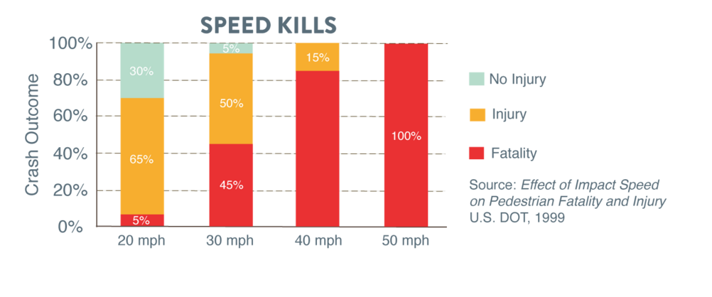
In November 2016, Trailnet hosted a traffic calming demonstration (check out the video and flyer!) on Louisiana Avenue next to Marquette Park to demonstrate what a Calm Street could look like on the corridor. During the demonstration, people driving slowed down by over 10 miles per hour. Ten miles per hour is the difference between someone struck by a car having a 5% chance of dying (with the concept installed) or having a 45% chance of dying (prior street layout).
Residents who witnessed the demonstration expressed their overwhelming support for the project, saying “we definitely need something to slow traffic” and “if you have to put a speed hump every six feet, I’m all for it!”
In 2017, the City of St. Louis submitted an application for federal funding, and the Louisiana Avenue Calm Street Project was chosen as the number one funding priority that year by the East-West Gateway Council of Governments.
Over the next five years, the City of St. Louis, its project partners and contractors jumped many hurdles on the way to creating a more streamlined process for building future Calm Streets in the City. The plan went for design in 2018, with construction beginning in 2021.
In spring 2023, construction was finished on Phase 1 of the Louisiana Calm Street Project. The first phase features 1.1-miles of assorted traffic calming measures (speed humps, mini traffic circles, high visibility crosswalks, bump-outs, rain gardens, etc.), from Gravois to Meramec.
Looking Ahead:
Phase 2 will extend the current Louisiana Avenue Calm Street South to Carondelet Park. Phase 2 is currently in design.
A third and final phase will extend North to Tower Grove Park and complete the North-South connection between two of our City’s largest and most-visited parks.
The goals of the Louisiana Avenue Calm Street Project are many:
To reduce speeds and increase safety for all road users,
To foster a sense of safety in the neighborhoods, schools and parks adjacent to the corridor,
To provide an alternative North-South connection in South City parallel to one of our most dangerous streets,
To encourage healthy, active living,
To test various, modern best practices for transportation engineering and traffic calming,
To develop a streamlined process for calming a network of streets across the City of St. Louis…
The finished vision for Louisiana is a safe > 3-mile corridor that connects thousands of people to the places that they live, work and play.
Phase 1 is completed, but this project still needs public support to be fully realized!
If you live in the neighborhoods that have been or will be touched by the Louisiana Avenue Calm Street, express your support to the City for safer streets. If you have feedback based on your experience of the corridor, reach out to your alderperson.
This pilot project will ultimately be a success if it paves the way for effective improvements to our built environment that save and better the lives of our neighbors! As one project partner from the City said at a recent presentation: “Maybe every street should be a Calm Street.”
“For example, vertical deflections (speed humps, speed tables, and raised intersections), horizontal shifts, and roadway narrowing are intended to reduce speed and enhance the street environment for non-motorists. Closures that obstruct traffic movements in one or more directions, such as median barriers, are intended to reduce cut-through traffic. Traffic calming measures can be implemented at an intersection, street, neighborhood, or area-wide level,” according to the US Dept. of Transportation. ↩︎
Spire and Trailnet Collaborate on New Bike Path at Bayless Elementary
A team of Spire volunteers constructed an all new walking and biking path on the property of Bayless Elementary School this summer!
The project was the result of a collaboration between Trailnet, Spire and Bayless Schools, funded by Spire Serves and carried out by volunteers through Spire’s Day for Good program.
The trail will connect the surrounding neighborhood with the school and provide awesome opportunities for bike education and recreation for Bayless students.
“We love opportunities like this,” said George Godat, Vice President and General Manager MoEast at Spire. “We provide opportunities for our employees to do a day of good in the community each year, and we also have dollars that we put into the community. Trailnet was able to apply for some funds from our Spire Serves program. We gave them $10,000 to provide the materials and labor, then our team came out and got to work. It was the perfect partnership for us and something we’re really excited about.”
Thanks to the Spire Team for cranking out a beautiful path that will result in years of recreation and bike education for our young neighbors!
Trailnet and the Missouri Chapter of the American Planning Association will be hosting a webinar on tactical urbanism on Thursday, March 2nd at 10am. The webinar will provide information about cross-sector collaboration and how it can have an impact on the built environment. Trailnet will also be sharing their success from the Plan4Health project. Learn more at Planners4Health. Register here.
What St. Louis can learn from the Cultural Trail in Indianapolis
What St. Louis can learn from the Cultural Trail in Indianapolis
In November, several Trailnet staff members decided to visit Indianapolis on their own time to check out the Cultural Trail and see how protected bikeways and walkways could help St. Louis. When they got back to work, the staff members pulled together several lessons learned from their vacation.
Here are a few highlights of what they learned:
The Cultural Trail is really two trails- a parallel sidewalk and protected bikeway, with landscaping and raingardens separating the routes in places. In St. Louis we need to make sure our design includes enough space for separate walking and biking routes, raingardens, and benches, public art, or sidewalk cafes.
Designing for everyone really does get everyone out walking and biking- people of all ages, abilities and backgrounds were enjoying the trail on foot and on bike.
The Cultural Trail has spurred development- for St. Louis, we need to make sure affordability and land use policy are part of the planning process so that our infrastructure is for everyone.
The trail was designed to make safe walking and biking a priority; at minor streets the trail was elevated to make sure cars slowed down. At stop lights the trail was marked with artistic and reflective crosswalks. All over the trail, public art celebrated the joy of walking, bicycling, and exploring the community.
At night the trail is well lit with lights that are designed to illuminate the paths for people walking and biking. The distinctive lights along the trail make it easy to navigate and increase safety.
Trailnet is moving forward with the first phase of the Master Planning Process for the new vision by determining the process for public input and feedback. To ensure our vision reflects the needs of St. Louis, Trailnet will be reaching out to key stakeholders in the next year. Trailnet will create a vision for everyone by gathering community input in many ways and working with residents, institutions, and local governments to answer difficult questions. This process will help our region make the important decision of determining routes, funding, and governance to make our vision a reality.
Starting in 2017, Trailnet staff and volunteers will be attending public meetings, distributing surveys, forming committees, conducting stakeholder interviews, and more in order to reach everyone in St. Louis to develop our vision into a master plan for connecting St. Louis.
Stay tuned for invitations on how to get involved and ensure your voice is heard.
Benton Park West utilizes traffic calming lending library
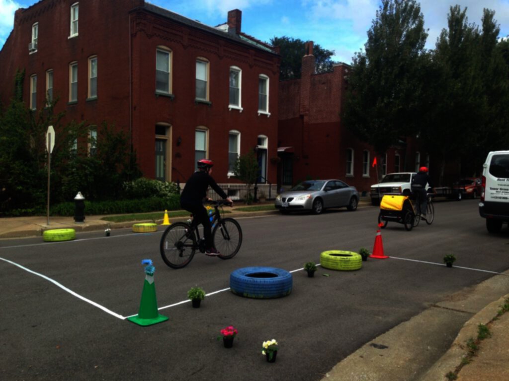
Trailnet has created a traffic calming lending library. That means anyone can rent out equipment for creating pop-up traffic calming demonstrations to show the community what it looks like when streets are designed to slow traffic. On October 2, the Benton Park Neighborhood Association hosted one of these demonstrations with our materials.
The demonstration consisted of two mini-roundabouts and curb extensions with a temporary crosswalk. Although the weather was cloudy, local politicians turned out for the event and showed interest in reviewing the neighborhood feedback.
“Trailnet’s traffic calming lending library allowed our neighborhood to turn safety concerns into visible solutions for the future,” said BJ Kraiberg, vice president of the Benton Park Neighborhood Association. “Our pop-up demonstration facilitated a necessary dialogue between neighbors, elected officials, and city employees, which would not have been possible without the thoughtful guidance of Trailnet staff and the Slow Your Street How-To Guide. Turning to Trailnet has proven to be an indispensable first step as we work towards building a safer, more walkable neighborhood and city.”
The BPNA said their next steps are to collect survey data, speed data, and stop compliance data on a non-demonstration day, then compare notes with data taken day-of.
For more information on Trailnet’s traffic calming lending library, contact Grace Kyung at planning@trailnet.org.
Trailnet staff recently traveled to Vancouver, British Columbia, where they presented at Pro Walk/Pro Bike/Pro Place, an international conference put on by People for Public Spaces. Below is a Q&A about what Bicycle and Pedestrian Planner Grace Kyung, Director of Policy and Strategy Marielle Brown, and with Trailnet Walk Bike Ambassador Deidre Brown experienced abroad.
What was the best idea you saw in Vancouver, B.C.?
Marielle) Grace and I stayed in a neighborhood north of downtown that had installed a lot of street closures in the 1970s to address crime. As crime went down, they had kept the closures for vehicles, but opened the streets for people by creating Calm Streets, where people can walk and bike safely with very low traffic. On some streets, the closures had been turned into small parks with benches and plants where neighbors could gather. This kept the street grid open for people on foot and on bike and encouraged local walking and biking trips. It made me think of how we can turn our street closures into assets for creating more people-friendly neighborhoods.
Grace) During my visit, one of the best ideas that I saw was how well connected the bicycle transportation network was throughout the city. I was impressed that Vancouver, B.C. focused on creating a strong network throughout the whole city to help people reach their destinations by bike. The city took it a step further because they analyze how many of their facilities are designed for people of all ages and abilities. The below image captures how well the city is focused on this initiative.
Photo credit – City of Vancouver in British Columbia, Canada
Further, the city’s approach to build protected bicycle lanes also showed the positive benefits to increase the number of women on bikes. From 2010 to 2015, the number of women biking grew to 40% after a protected bike lane was built.
Deidre) What I like most about Vancouver, is how the city makes cyclists and pedestrians a priority. They performed “road diets” throughout the city in order to slow traffic and allow room for protected bike lanes. I love their use of bike traffic signals, which are like the ones we use for cars. These signals work in conjunction with the regular traffic signals and the pedestrian cross walk signals to protect pedestrians and cyclists. It was such a joy to see so many pedestrians and cyclists take advantage of what the city has provided them. Vancouver is a city that truly puts pedestrians and cyclists first, before cars.
Which community and which projects inspired you most?
M) The energy and ambition of Twin Cities Greenways in Minneapolis is amazing. They are a group of advocates and residents working together to create a car-free corridor for biking and walking in north Minneapolis, where there are no abandoned rails to convert to greenways. The project has been resident-driven from the start and right now they are doing demonstrations to test out different concepts. The greenway will not only improve the quality of life for residents, it will also change what we consider possible for street design in the U.S.
The City of Calgary’s year-long demonstration of a network of protected bikeways was very inspiring. The City decided to test out the idea of protected bikeways by creating a basic network of them downtown using paint, bollards, and other temporary changes. The test has been very successful and Calgary will be working on making the protected bikeways permanent. By demonstrating several connected routes at once, Calgary ensured that their protected bikeways would be useful and highly used.
G) The session that inspired me the most during the conference was “Overcoming Barriers to Bicycling in Communities of Color” by Charles Brown and Robert Schneider. One of the most important takeaways for me was that planners and other professions must acknowledge it is okay to not have all the answers, but important to ask the right questions without making assumptions. Also, we should be giving people of color the microphone and paying them for their time to participate rather than asking them to only volunteer.
D) While in Vancouver, I had an opportunity to take a walking tour of Olympic Village, which is where the athletes stayed during the 2010 Winter Olympics. When Olympic Village was designed, it was designed for everyone. There are a mixture of high-end condominiums and affordable housing, which was a requirement when developing the Village.
There were two things that really impressed me with Olympic Village: One was its mixed-use buildings and the other was how accessible it is for people with mobility challenges. A lot of buildings in Olympic Village were designed as mixed-use buildings with stores and other businesses on street level and apartments on higher levels. It is a self-contained community with everything you need within walking distance of where you live, except a school, which they are in the process of planning.
What is your biggest takeaway from the conference?
M) My biggest takeaway was that St. Louis needs robust public engagement in our land use and transportation decisions. When we allow decisions to be made behind closed doors, we can miss out on important considerations and fail to see new, transformative ideas that can improve the places we live and give us more transportation options. When we work together as a community to address problems and test out solutions, it helps build consensus around projects and get people excited for improving their neighborhoods, rather than being leery of any change.
G) The biggest takeaway from the conference for me was that Trailnet is doing great work, but can continue to improve as leaders in our community. In my role at Trailnet, I focus on creating more livable, vibrant, healthy communities. As a planner, and I would like to expand on this perspective by working with city and community stakeholders to build better cross-sector collaborations. In my role, I need to think about ways I can work to continue to build capacity throughout the city, and find better ways for Trailnet to partner with neighborhoods to form a collective vision.
D) My biggest takeaway was that if we are going to make St. Louis a more livable city, we have to have buy-in from everyone; from the elected officials to the residents. We must involve the people who live, work, play, attend schools; the people who make it a community. It has to be a collaboration. When you include the people of the community, it gives them a sense of ownership, a sense of pride in knowing that they are a part of what is going on in their community and in knowing that their voice matters.
Furthermore, we must change our way of thinking when it comes to planning and designing new communities as well as making changes to existing communities. We must make pedestrians and biyclists a priority over cars.
Woodward Elementary School gets new traffic calming features
In the fall of 2015, the Missouri Chapter of the American Planning Association collaborated with Trailnet, the Healthy Eating Active Living (HEAL) Partnership, the City of St. Louis, the Missouri Public Health Association, and community residents to tackle the concern of traffic-related deaths by hosting four pop-up traffic calming demonstrations within the City of St. Louis through the Plan4Health program.
Plan4Health connects communities across the country, funding work at the intersection of planning and public health. Anchored by the American Planning Association (APA) and the American Public Health Association (APHA), Plan4Health supports creative partnerships to build sustainable, cross-sector coalitions.
The successful demonstrations implemented by Trailnet showcased proven methods of slowing traffic and increasing safety with traffic calming designs. The demonstrations were used to educate community members, elected officials, and city staff on how we can work together to create safer, more vibrant, and healthier communities. These educational events have the potential to influence policy change for better street design.
Further, the demonstrations help visualize safer streets, which can lead to healthier communities and encourage active lifestyles. They are also an opportunity for the community to come together and start a dialogue on how we can work together to improve our street designs.
Through the positive conversations spurred by the pop-up traffic calming demonstration, Trailnet worked with BJC School Outreach and Youth Development to plan permanent street design changes by Woodward Elementary School with the City of St. Louis. The location was chosen to increase visibility and safety of the children and families crossing the street to travel to and from school on foot. The changes included an updated crosswalk, curb ramps, a bump out, and stop lines to enhance the crosswalk by the school. The improvements were funded by the Missouri Foundation For Health’s Healthy Schools Healthy Communities program.
Trailnet celebrated the permanent changes at a ribbon-cutting event hosted by the BJC School Outreach and Youth Development staff. The pop-up traffic calming demonstrations led to positive change within the community in under one year! This achievement would not have happened without the support of all those that have been involved with the project. Trailnet is excited to continue to promote safer street designs by using pop-up traffic calming demonstrations.
To learn more about the program please contact Trailnet at planning@trailnet.org.
Traffic calming demonstrations produce promising data
In fall of 2015, the Missouri Chapter of the American Planning Association collaborated with Trailnet, the HEAL Partnership, the City of St. Louis, and community residents to host four pop-up traffic calming demonstrations within the City of St. Louis. The demonstrations showcased proven methods of slowing traffic and increasing safety with traffic calming designs. The Missouri Chapter of the American Planning Association, Trailnet and the HEAL Partnership used these demonstrations to educate community members, elected officials, and city staff on how we can work together to create safer and more pleasant streets.
Like most U.S. cities, the St. Louis designed its streets to prioritize people driving, making our city less pleasant and less safe for people on foot. In the U.S., 12 percent of fatal traffic crashes involve people walking; however, in St. Louis that figure is 36 percent. Last year, 19 pedestrians were killed in the City of St. Louis. In fact, more pedestrians were killed in 2015 than in 2013 and 2014 combined. These sobering statistics earned St. Louis a designation as a Focus City by the National Highway Traffic Safety Administration, joining 16 other U.S. cities in which pedestrian and bicycle deaths are higher than the national average.
These crashes are a consequence of streets designed to accommodate streetcars and high levels of traffic. For example, some residential streets in St. Louis are as wide as 65 feet, which is wide enough for five highway lanes. This encourages excessive speeding and puts people that walk in danger. Moreover, high-traffic, high-speed roads create impassable boundaries that effectively turn neighborhoods into “islands” for people walking. For households that do not have any cars, high stress roads limit access to important amenities, such as parks and schools. Pedestrian safety is a growing concern in St. Louis, and traffic calming can help solve this problem by slowing down vehicles and prioritizing safe and pleasant streets over moving traffic.
At the pop-up traffic calming demonstrations in the neighborhoods of Dutchtown, Carondelet, JeffVanderLou and the Ville, colorful tires, cones and plants were used to narrow traffic lanes, add roundabouts, create medians, extend sidewalks, and highlight crosswalks. In each neighborhood, speed guns were used to collect speed data; trained volunteers observed and tallied vehicular stops as “completely stopped,” “rolling stop, or “no stop” and Trailnet surveyed residents of the neighborhood on their perceptions of the street’s safety and accessibility. Data was collected during the demonstrations as well as on non-demonstration days to help understand how traffic calming impacted the neighborhoods.
With traffic calming measures in place, cars drove slower, came to more complete stops, and were less likely to roll through stop signs. Residents expressed that their local streets felt safer and more pleasant. During the traffic calming demonstrations, residents said it was easier to cross the street since it was more likely cars would obey stop signs and follow the speed limit. In most neighborhoods, the survey results indicated the traffic calming demonstrations improved residents’ perceptions of the street’s safety, and most residents expressed that the demonstrations made their street feel more pleasant.
Trailnet looked at average differences in response taken during demonstrations as well as without a demonstration in place. In most neighborhoods, the survey analysis showed the demonstrations results were positive in regards of safety.
The only exception was in the Dutchtown neighborhood (Gasconade Street between Compton Avenue and Minnesota Avenue). While some of the survey results in Dutchtown were negative, the survey analysis suggests that these differences might have been random occurrences. These results can be partly explained by the fact that some residents were hesitant with certain aspects of the Dutchtown demonstration. For example, some residents felt they weren’t well enough informed about the traffic calming demonstrations and were upset to have parking spaces were removed from the street. also, some residents were hesitant about one of the proposed traffic calming designs; the chicane, which causes drivers to swerve slightly. Residents feared the design would turn Gasconade Street into a one-way street. In reality, this feature maintains a two-way street with enough space to have two cars pass each other.
Overall, in all four neighborhoods, average vehicle speed fell nearly 7 mph with the traffic calming demonstrations in place. When pedestrian crashes do occur, slower vehicle speeds result in fewer pedestrian deaths.
The Ville demonstration (St. Louis Avenue between Sarah Street and Whittier Street) was especially successful with the average vehicle speed falling nearly 13 mph and the number of complete stops during the demonstration increasing from 34 percent to 65 percent. The demonstration site was served by four bus stops, so the increased stops helped people to get to their buses safely throughout the day.
Because of the success of these events, Trailnet is making the resources from these demonstrations available for free to any organization or St. Louis neighborhood wanting to create a similar demonstration in their community. For information on accessing these materials, contact Grace Kyung at grace@trailnet.org or 314-436-1324 ext. 110.
To see the full results from these demonstrations see the infographic below.


 In the fall of 2015, the Missouri Chapter of the American Planning Association collaborated with Trailnet, the Healthy Eating Active Living (HEAL) Partnership, the City of St. Louis, the Missouri Public Health Association, and community residents to tackle the concern of traffic-related deaths by hosting four pop-up traffic calming demonstrations within the City of St. Louis through the Plan4Health program.
 Plan4Health connects communities across the country, funding work at the intersection of planning and public health. Anchored by the American Planning Association (APA) and the American Public Health Association (APHA), Plan4Health supports creative partnerships to build sustainable, cross-sector coalitions.
 Through the positive conversations spurred by the pop-up traffic calming demonstration, Trailnet worked with BJC School Outreach and Youth Development to plan permanent street design changes by Woodward Elementary School with the City of St. Louis. The location was chosen to increase visibility and safety of the children and families crossing the street to travel to and from school on foot. The changes included an updated crosswalk, curb ramps, a bump out, and stop lines to enhance the crosswalk by the school. The improvements were funded by the Missouri Foundation For Health’s Healthy Schools Healthy Communities program.
 Like most U.S. cities, the St. Louis designed its streets to prioritize people driving, making our city less pleasant and less safe for people on foot. In the U.S., 12 percent of fatal traffic crashes involve people walking; however, in St. Louis that figure is 36 percent.