The Louisiana Avenue Calm Street Project
A decade in the making, this North-South corridor in South St. Louis is undergoing transformations that could change the way St. Louis streets are designed and improved in the interests of vulnerable road users.
2013 – 2014: Project Background
In 2013, Trailnet and our partners in the City of St. Louis received an EPA grant to educate and engage the St. Louis Community about traffic calming.
Traffic Calming – Traffic calming consists of physical design and other measures put in place on existing roads to reduce vehicle speeds and improve safety for pedestrians and cyclists. 1

From 2013 – 2014, Trailnet helped to educate more than 1,200 residents in Dutchtown, Forest Park Southeast, and North City through mapping, community meetings and neighborhood outreach.
The communities we worked with became excited about increasing pedestrian and cyclist safety by transforming neighborhood streets into what were then referred to as neighborhood greenways and bicycle boulevards, now known locally as Calm Streets.
Calm Streets – A Calm Street is a residential street transformed to reduce speeding and provide safety for everyone traveling there. Using traffic calming features such as speed humps and curb extensions, Calm Streets create an environment where people drive the speed limit and therefore preserve the safety of people walking and biking. They also incorporate green infrastructure to mitigate stormwater issues and address environmental concerns like the urban heat island effect.
2015: A Formative Trip to Portland
In 2015, Trailnet secured a second round of EPA grant funding, which was used to fly a group of project partners, city officials and residents to Portland, Oregon, where they took inspiration from the Portland Bureau of Transportation’s Neighborhood Greenways Program.
Full of ideas and bolstered by concrete evidence of the plausibility and effectiveness of neighborhood-, and city-wide traffic calming projects, the team returned to St. Louis to choose a location for a pilot project.
At the time, Trailnet was working with Froebel Elementary School in the Dutchtown Neighborhood on creating safe routes to school for their students. Through that project, Trailnet had already established residents’ desires for safer streets in their neighborhoods and begun to build political willingness to act in the Dutchtown Community—which has the highest concentration of school-aged children in the City of St. Louis.
With that groundwork already done in the Dutchtown community, Louisiana Avenue was chosen as the pilot site for the City of St. Louis’ Calm Streets Concept. The rationale: Louisiana was an ideal North-South connection, parallel to the City’s highest crash corridor (Grand Blvd.) and adjacent to many parks, schools, small businesses and residential streets. Thus began the process of planning, designing and constructing what would become the Louisiana Avenue Calm Street.

2016 – 2023: Pop-ups, Planning and Construction

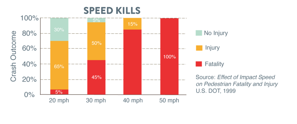
In November 2016, Trailnet hosted a traffic calming demonstration (check out the video and flyer!) on Louisiana Avenue next to Marquette Park to demonstrate what a Calm Street could look like on the corridor. During the demonstration, people driving slowed down by over 10 miles per hour. Ten miles per hour is the difference between someone struck by a car having a 5% chance of dying (with the concept installed) or having a 45% chance of dying (prior street layout).
Residents who witnessed the demonstration expressed their overwhelming support for the project, saying “we definitely need something to slow traffic” and “if you have to put a speed hump every six feet, I’m all for it!”

In 2017, the City of St. Louis submitted an application for federal funding, and the Louisiana Avenue Calm Street Project was chosen as the number one funding priority that year by the East-West Gateway Council of Governments.
Over the next five years, the City of St. Louis, its project partners and contractors jumped many hurdles on the way to creating a more streamlined process for building future Calm Streets in the City. The plan went for design in 2018, with construction beginning in 2021.
In spring 2023, construction was finished on Phase 1 of the Louisiana Calm Street Project. The first phase features 1.1-miles of assorted traffic calming measures (speed humps, mini traffic circles, high visibility crosswalks, bump-outs, rain gardens, etc.), from Gravois to Meramec.
Looking Ahead:
Phase 2 will extend the current Louisiana Avenue Calm Street South to Carondelet Park. Phase 2 is currently in design.
A third and final phase will extend North to Tower Grove Park and complete the North-South connection between two of our City’s largest and most-visited parks.
The goals of the Louisiana Avenue Calm Street Project are many:
- To reduce speeds and increase safety for all road users,
- To foster a sense of safety in the neighborhoods, schools and parks adjacent to the corridor,
- To provide an alternative North-South connection in South City parallel to one of our most dangerous streets,
- To encourage healthy, active living,
- To test various, modern best practices for transportation engineering and traffic calming,
- To develop a streamlined process for calming a network of streets across the City of St. Louis…
The finished vision for Louisiana is a safe > 3-mile corridor that connects thousands of people to the places that they live, work and play.
Phase 1 is completed, but this project still needs public support to be fully realized!
If you live in the neighborhoods that have been or will be touched by the Louisiana Avenue Calm Street, express your support to the City for safer streets. If you have feedback based on your experience of the corridor, reach out to your alderperson.
This pilot project will ultimately be a success if it paves the way for effective improvements to our built environment that save and better the lives of our neighbors! As one project partner from the City said at a recent presentation: “Maybe every street should be a Calm Street.”
More Resources:
- Louisiana Calm Street Pilot Project FULL Report
- NACTO Urban Bikeway Design Guide
- 2017 NextSTL Article on the Calm Street Pilot Project
- Froebel Elementary / Dutchtown Traffic Calming Timeline
- Terrain Magazine Reports from a Walking Tour of the Completed Calm Street
- “For example, vertical deflections (speed humps, speed tables, and raised intersections), horizontal shifts, and roadway narrowing are intended to reduce speed and enhance the street environment for non-motorists. Closures that obstruct traffic movements in one or more directions, such as median barriers, are intended to reduce cut-through traffic. Traffic calming measures can be implemented at an intersection, street, neighborhood, or area-wide level,” according to the US Dept. of Transportation. ↩︎

 Like most U.S. cities, the St. Louis designed its streets to prioritize people driving, making our city less pleasant and less safe for people on foot. In the U.S., 12 percent of fatal traffic crashes involve people walking; however, in St. Louis that figure is 36 percent.