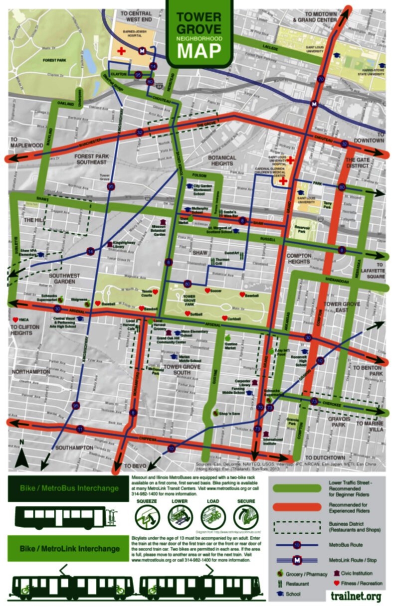
This map was developed by Trailnet in partnership with Tower Grove neighborhoods to help residents and visitors get to and from destinations in the neighborhood by bicycle or bus.
The map shows routes for Beginner Riders and Experienced Riders. The Beginner routes are generally on lower-traffic streets with slower vehicles. The Experienced routes are typically higher traffic, but may include bike lanes.
Funding for this project was provided in part by The Missouri Foundation for Health (MFH). MFH is a philanthropic organization whose vision is to improve the health of the people in the communities it serves.
Trailnet thanks MFH and the alderpeople and neighborhood associations of the area this map serves.
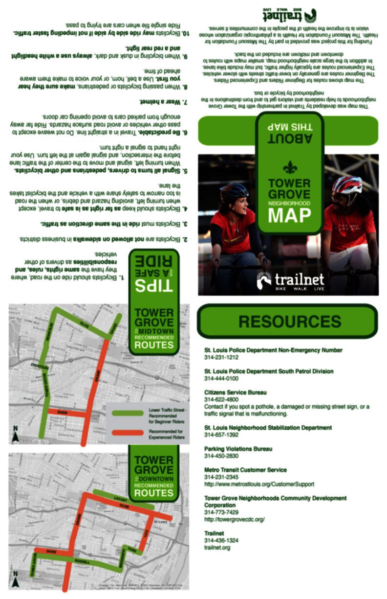
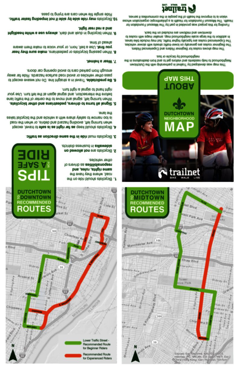
This map was developed by Trailnet in partnership with the Dutchtown Neighborhood to help residents and visitors get to and from destinations in the neighborhood by bicycle or bus.
The map shows routes for Beginner Riders and Experienced Riders. The Beginner routes are generally on lower-traffic streets with slower vehicles. The Experienced routes are typically higher traffic, but may include bike lanes. In addition to the large scale neighborhood map, smaller maps with routes to downtown and midtown are included.
Funding for this project was provided in part by The Missouri Foundation for Health (MFH). MFH is a philanthropic organization whose vision is to improve the health of the people in the communities it serves.
Trailnet thanks MFH and the alderpeople and neighborhood associations of the area this map serves.
Click on the map to download a pdf.
Campaign Videos
Thank you to all of our volunteers for helping us spread the word: We Know A Better Way.
This campaign was made possible by funds from the Federal Highway Administration through the Congestion Mitigation and Air Quality (CMAQ) Program, sponsored by the Missouri Department of Transportation.
Thank you to all of our volunteers – the stars of this campaign.
[AFG_gallery id=’2′]
This campaign was made possible by funds from the Federal Highway Administration through the Congestion Mitigation and Air Quality (CMAQ) Program, sponsored by the Missouri Department of Transportation.
Shift Your Commute: Listen the Stories of Commuters
Bike Count Data
Thank you to our volunteers who helped us count cyclists and pedestrians at 103 locations throughout the St. Louis Metro region this past September. Collecting such extensive data can be a real challenge, and it would not have been possible without them. We have summited the data to the National Bicycle and Pedestrian Documentation Project.
Despite the dangerously high temperatures, significant increases were observed at several locations.
Sit down and count
Trailnet volunteers have stepped up to sit down and count people on bikes and on foot. If you have not signed up already I hope you will!
On Tuesday and Wednesday of next week (September 10 and 11) bike/pedestrian counters will be seen at 132 locations throughout St. Louis City, St. Louis County, and St. Charles County, from 5:00 to 7:00 p.m., finding out where people are biking and walking. And where they’re not.
The data they gather will be used to inform local decisions about bicycle and pedestrian networks. It will also be added to a national database of statistics, and will help to refine bike/ped forecasting.
Filling these slots has been a big undertaking and the response from our volunteers has been impressive. We have 88 slots filled and 29 left to fill. We have a sweet incentive this year – for each slot you fill, your name will be entered in a drawing for an iPad.
The information we collect and record through these counts, which is being done in partnership with Great Rivers Greenway, is essential for so many reasons. Some of you may remember receiving an American Community Survey (the form that replaced the long form census) that asked about how you commuted, and gave you the chance to identify biking or walking. But it didn’t ask you if you walked or rode your bike for other reasons, and that represents more than half of all trips! Counts are a way to capture trips for all purposes.
Counters are also on the lookout for cyclists on sidewalks and cyclists riding against traffic. These numbers will be taken into consideration when decisions about education campaigns are made.
The home page of the National Bicycle and Pedestrian Documentation Project explains it best: one of the greatest challenges facing the bicycle and pedestrian field is the lack of documentation on usage and demand. Without accurate and consistent demand and usage figures, it is difficult to measure the positive benefits of investments in these modes, especially when compared to the other transportation modes such as the private automobile. This nationwide count provides a consistent model of data collection and regularly updated data for use by planners, governments, and bicycle and pedestrian professionals.
My deepest thanks go to Trailnet’s many volunteers and staff who donate their most precious resource, their time, to this important project. Please check your calendar and see if you can take a shift or two. Your volunteer hours will provide invaluable information.
Thank you.
Campaign Kickoff and Volunteer Thank You Party Photos
Thank you to everyone who came out for our campaign kickoff and volunteer thank you party held at the Schlafly Tap Room. Special thanks to STL Style for helping us promote the party and campaign.